
Enquiries
Inquiry Email
Product Introduction
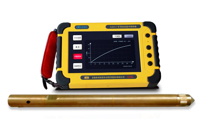
The YZG6.4 mine-used borehole trajectory measuring instrument is a compact, lightweight, highly accurate, and stable trajectory measuring device. It is suitable for trajectory measurement work as specified in the "Detailed Rules for Coal Mine Water Prevention and Control" and the "Implementation Rules for Gas Management". It can be used for trajectory measurement of gas drainage holes, geological holes, and other boreholes, and is widely applied in borehole measurement fields such as coal mines and geological exploration. In 2019, this type of product was selected as an advanced and applicable technical equipment for coal mine safety - the "Intelligent Borehole Trajectory (Parameter) Calibration Instrument".
Main Features
1. Intelligent and Portable Host: The host uses a mine-used handheld terminal, which is lightweight, intelligent, and easy to operate. It can directly generate graphs on - site and display two - dimensional inclination measurement data.
2. Multifunctional: The host can also be used as an explosion - proof camera, intelligent terminal, and for other functions.
3. High Precision: The current measurement accuracy is [Inclination] ±0.1° and [Azimuth] ±1.0°.
4. Easy to Use: It does not require dedicated drilling rigs and cable - passing drill pipes.
5. Long - lasting Probe: The working time of the probe can reach up to 30 hours.
6. Large Storage Space: With a 32GB space, it can store a large amount of data.
7. 3D and Multi - hole Display: It can achieve 3D display of boreholes and combined display of multiple holes.
Application Examples
Plan View of Borehole 1, Average Azimuth Angle: 129.4°
East
South
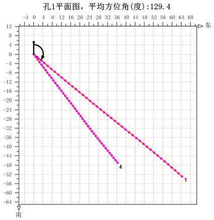
Projection of Double Water - exploration Holes in a Drilling Field of a Mine Group on the Horizontal Plane (XY Plane): This projection separately reflects the azimuth angle of the borehole.
Profile View of Borehole 1, Average Inclination Angle (degrees): 7.8°
Vertical Height
129.4°

Projection of Double Water - exploration Holes in a Drilling Field of a Mine Group on the Vertical Plane: This projection separately reflects the inclination angle of the borehole.

3D Space Trajectory of Double Water - exploration Holes in a Drilling Field of a Mine Group: It shows the 3D trajectory of the boreholes.